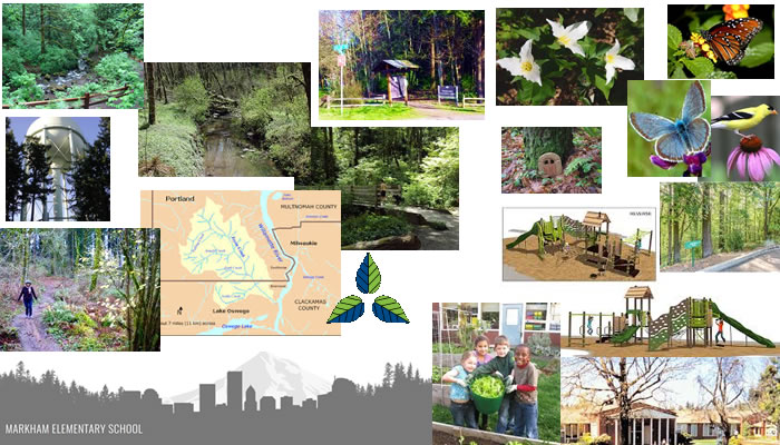
Markham neighborhood collage of pictures telling the unique features of Markham
Markham neighborhood stretches along I 5 just south of it and Barbur Blvd, with east boundary being Taylor’s Ferry, to Lancaster, to Maricara to 35th and back up to I 5, bordering the neighborhoods of Multnomah and South Burlingame on the north, Marshall Park on the east, Arnold Creek on the south, and West Portland Park on the west. Because it stretches along I 5, some of the upper neighborhood has noise from the freeway. The Markham Neighborhood itself doesn’t have much in the way of shops or restaurants, especially nothing with character or charm. You can find things right on Barbur, but you have to cross I 5 to get to it. 26th goes under the freeway and Barbur, so if you take SW 26th, you can get to Barbur, but also you can walk to Multnomah Village! One other thing about this neighborhood, there is an onramp to I 5 south, and they are few and far between! So it is easy freeway access to downtown.
Markham Neighborhood feels like a suburb, going down into the trees from I 5, with winding, hilly streets, barely any sidewalks, away from civilization. Because it is so close to I-5 freeway, it is an easy commute to downtown, which makes it popular for those working in the city, yet want to raise their families in a more peaceful and traditional neighborhood. Houses range from affordable, to expensive, with a few 30’s and 40’s, but mostly from the 50s on up, kind of a mixed age neighborhood that had big lots that were divided as time went on, and new houses built wherever there was room. You can find the more affordable homes along Taylor’s Ferry, and up close to the freeway. As you get down into the neighborhood, most of the houses are alot higher in price.
Markham elementary had 5th graders plan, plant and study a native habitat garden
The Markham elementary school, 5th grade, took on the project of turning some of their expansive lawns into a native habitat garden. The students planned their garden, purchase the plants and other supplies, and then joined in the fun on planting day. They also partnered with a local bee enthusiast to introduce stingless native Orchard Mason Bees to their garden, and then studied their foraging and nest building behavior as a class project.
Maricara Natural Area, which is quite large at 17 acres, is part way in the neighborhood. This park feels more like a natural retreat than many Portland areas. It has huge trees and 2600 feet of trails. It also has a wetland and protected stream! Marshall Park is also conveniently located for Markham residents. This area has a 400 foot wide canyon with nature trails within it. It also has a cute waterfall. The neighborhood also almost borders the very top of Tryon Creek State Park, which is amazing for hiking, and 2 creeks flow through it, Falling creek and Tryon Creek.
Parks in Markham Neighborhood
Maricara Natural Area
is a beautiful hidden natural area tucked into the neighborhood, with 17 acres, no parking or way for alot of people to access it, so used mostly by people who can walk to it. Maricara Natural Area consists of mostly second-growth Douglas fir and Big Leaf Maple woodlands. The forest surrounds a wooded wetland area which is the headwaters for a small stream that flows into Arnold Creek, then on to Tryon Creek and the Willamette River. The elevation between any two points in the park only differs by about 100 feet, so it isn’t a steep hike, meaning good for little ones!
Marshall Park Rustic park set in the middle of a canyon with wooded hiking trails & picnic areas.
Jensen Natural Areais a small 2 acre natural area
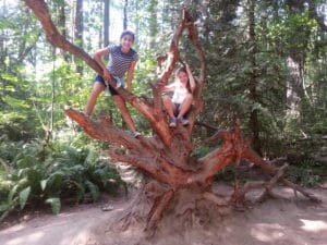
This is us in Tryon Creek Trail.
Tryon Creek State Park is really close to the neighborhood. The park includes hiking trails, a paved bicycle path, and horse trails. The 3-mile bicycle path, going along Terwilliger Boulevard on the east edge of the park to Lake Oswego, is part of the Portland metropolitan area’s system of Greenway trails known as the 40 Mile Loop. Near the main entrance off Terwilliger, part of the parking lot is devoted to horse trailers.You can ride horses on the 2-mile North Horse Loop or the 3-mile West Horse Loop. Hikers can use the bike path, the horse trails, and 8 miles of hiking trails. The paved 0.35-mile Trillium Trail, has drinking fountains and interpretive signs, can accommodate wheelchairs, has benches and two viewing decks. A park building called the Nature Center is near the main park entrance. It has a small play area for toddlers, a gift shop, a large classroom, and a separate area for educational exhibits. Nearby is the Glenn Jackson Shelter, a covered structure for outdoor events. Here is a map to all the trails
Other Important Links
The MAX and buses make public transportation really good!
Schools In Portland- people are permitted to send their children to whatever school they want within the Portland School District, as long as there is room. If the school is important to you, it is probably a good idea to check and see which school your neighborhood is assigned to- because it seems logical that the best schools will have a waiting list- and if you live there, you will be at the top! Find your school attendance area or a school site and view the boundary area using School Locator Page for: Portland Public Schools..
Read how to use the interactive map by clicking on the (Information) icon (circle with an i in the center).
School Report Cards for schools and districts in Oregon. Select (Portland SD 1J) In the District Selection Heading to view individual schools within the Portland Public School District.
You can find all kinds of All kinds of information about crime, maps, etc, Portlandmaps.com even exactly what happened where, if you just put in an address in Portland. There are lots of other things you can learn there- like census information, maps, school info, parks, environmental issues, permits on houses, nuisance complaints and taxes.


")


