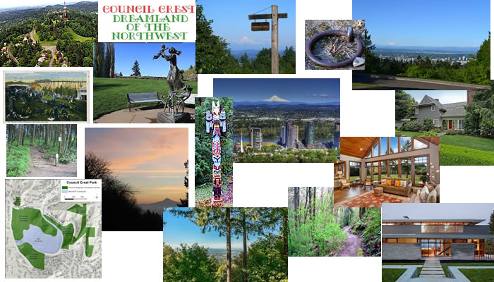
Council Crest Neighborhood Collage
Council Crest neighborhood is a gorgeous area of winding roads and hills with forest and views throughout. Council Crest is the highest point in the West Hills, which are really the Tualatin Mountains. It is 1071 feet above sea level! From the top on a clear day you can see from Mt Hood to Mt Rainier! Many homes have views of the Cascade mountain range- including Mt Hood, Mt St Helens, Mt Adams and even Mt Rainier- also the Willamette River, and the city lights of downtown! A lot of the homes are built on the side of the hill and are cantilevered over the forest floor or valley below. As many of the streets in this area wind through the tree-lined forest, this makes the West Hills an cool place to explore, and a serene and beautiful place to live! Houses range in price up to $3,000,000 and above!
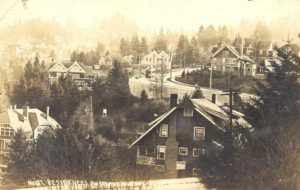
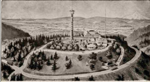
Here is Council Crest back in early 1900s
Council Crest neighborhood first was claimed back in 1851- According to legend, it got its name because it was here that Native Americans held meetings and built signal fires. Others say that it was named in 1898 by delegates to the National Council of Congregational Churches, who met on the top.
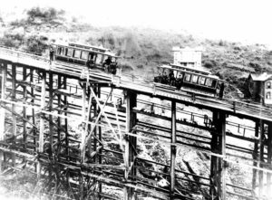
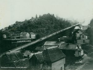
Early Cable car trestle-looks pretty scary!
The water tower that now stands atop Council Crest used to be a 77-foot tall wooden observatory- which was part of the amusement park that was there from 1907 to 1929. In 1936, the city bought the land and created Council Crest Park. The Portland Street Car helped development of this area- which was pretty steep and high above the city- and then in 1926 the Fourth Street Bridge, which later became the Vista Bridge, helped it grow.
The houses are a variety houses which include- historic stately Mansions, charming turn of the century English and Cape Cod, modern Mid-Century and stunning modern Contemporary. Many of them have spectacular views of the city or valley.
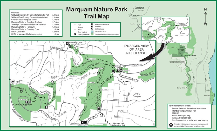
Council Crest Park is at the top of the mountain. The views are spectacular and Panoramic so you can see the Mountains to the East and North, the City, the River and the countryside to the West. There are trails that hook to Washington Park and if you walk through the neighborhood you can get down to the Marquam Park trails.
Location is perfect if you work at OHSU or Downtown. Residents say they love the proximity to NW 23rd and Downtown Portland. It is literally just minutes to a performance at the “Schniz” or dinner at a romantic spot on NW 23rd.
Parks in Council Crest neighborhood
Council Crest Park Council Crest Park is a beautiful park in the hills right above Portland, one of the highest points there is. On a clear day you can see 5 snow capped mountains, Mt Hood, Mt St Helens, Mt Adams, Mt Rainier and even Mt Jefferson. You can either drive up to the top, or you can hike. There are several trailheads, one of the longest and prettiest is to begin at the Marquam Trail, which is really a trail connector, connecting Washington Park to the Willamette River, or up to Council Crest. Going up to Council Crest, it cuts through many neighborhoods, and across streets, then goes up sharply. You have to climb to about 1000 feet elevation.
History of Council Crest Neighborhood
Showing the cable line going up to the top of Council Crest
The land claim that included Council Crest neighborhood was done in 1851, but the hills were too steep, the roads too muddy, to reach Council Crest. Once the roads were paved and the Vista Bridge was built in 1903, land prices quickly went from a few hundred dollars an acre to $10,000 by 1910. The Portland Cable Railway started running a cable car up Vista Avenue to Council Crest Park in 1890, and that changed everything! The railway company developed a cable-car line that ran between Union Station and Portland Heights.
Historic Council Crest
From the train station, the cars would head south toward the center of town on Southwest Fifth Street, then go up 1,040-foot wooden trestle that carried the cable cars from Goose Hollow up the line to Council Crest at the top. It kept going for 14 years, until it became unsafe to run. Today, that is the same location of the Goose Hollow Max Station.
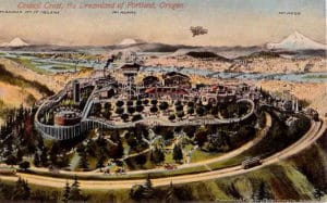
Council Crest Park back in early 1900s
Council Crest neighborhood was “Portland’s roof garden on the mountaintop.” From Council Crest, on a clear day, you can see five snow-capped peaks and 3,000 square miles of land and rivers that connect them together. In 1907, an amusement park was built on top of the hill, and opened on Memorial Day in 1907. The Portland Railway light and Power company is the one that initiated the park because they wanted more people to ride the Portland Heights Streetcar.
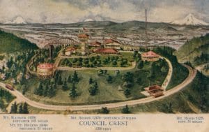
Council Crest Park had an amusement park at one time
The Council Crest Tavern featured Mt. Hood Ice Cream as well as confections, fruits, candies, cigars, tobacco and soft drinks. Pittmon’s Guide for 1915 described the trip on the Portland Heights streetcar line to Council Crest as “One of the most beautiful trolley rides in the world, taking you in 20 minutes from the heart of the business district to the height of 1073 feet, unfolding before you a scenic panorama for grandeur unexcelled. The hustling city in the foreground nestling on both banks of the Willamette River is 12 miles from its confluence with the Columbia River.” It closed in 1929 after the big stockmarket crash, and it wasn’t until 1836 that the city of Portland bought the land and created Council Crest Park.
Other Important Links
The MAX and buses make public transportation really good!
Schools In Portland- people are permitted to send their children to whatever school they want within the Portland School District, as long as there is room. If the school is important to you, it is probably a good idea to check and see which school your neighborhood is assigned to- because it seems logical that the best schools will have a waiting list- and if you live there, you will be at the top! Find your school attendance area or a school site and view the boundary area using School Locator Page for: Portland Public Schools..
Read how to use the interactive map by clicking on the (Information) icon (circle with an i in the center).
School Report Cards for schools and districts in Oregon. Select (Portland SD 1J) In the District Selection Heading to view individual schools within the Portland Public School District.
You can find all kinds of All kinds of information about crime, maps, etc, Portlandmaps.com even exactly what happened where, if you just put in an address in Portland. There are lots of other things you can learn there- like census information, maps, school info, parks, environmental issues, permits on houses, nuisance complaints and taxes.


")


