Pleasant Valley neighborhood is a large neighborhood in SE Portland that is just north of Happy Valley.
Pleasant Valley neighborhood is part urban, part rural, still in Multnomah County, but in the outer edges of it. It is still possible to get a little bit of land in the Pleasant Valley neighborhood, although most lots are divided, and houses are built on the newly divided lots. Houses here are much more affordable than in the neighborhoods closer to Portland, and it is a more suburban feel with bigger yards and lots more open space than in the city, including 608 acre Powell Butte Nature Park, which is an extinct Volcano which rises up right near the headwaters of Johnson Creek. Powell Butte has trails for hiking, walking your dog, even riding horses, and there are some amazing views of Mt Hood from the top.
There are all types and sizes of homes in this neighborhood, some urban and some more rural. The houses range from craftsman bungalows and Tudor cottages to mid-century ranches and modern town homes and apartments. This area is much more affordable than the inner neighborhoods.
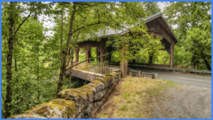 There is a historic covered bridge in the Pleasant Valley neighborhood, on SE Deerdorff Rd off of Foster Road, called Cedar Crossing.
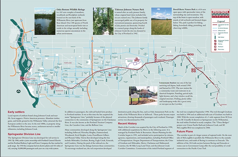
Clatsop butte Park, The Clatsop Butte Trail is an interim 8’ wide wood chip path that gently meanders atop a butte within the City of Portland while offering grand views of downtown Portland, Mt. Hood, Mt. Adams and Mount St. Helens. The project work included a 0.6 mile long wood chip trail using ADA engineered wood chips, a park site sign, trail signs and two benches located to take advantage of the great views.
The Johnson Creek headwaters start in Pleasant Valley near Powell Butte. Johnson Creek watershed covers 140 square miles, with only 5 percent 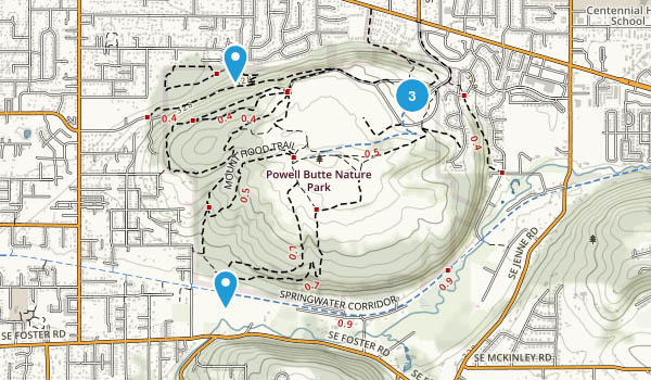 being parks and open spaces. Salmon runs on Johnson Creek used to be huge, and fed the Native Americans and the early settlers. In fact, they say thatfall salmon runs being so thick that you could walk across the creek on their backs or catch them with a pitchfork. There is still lots of wildlife. Mammals such as river otter, beaver, nutria, raccoons, and possum are common along the 46km stretch of the Watershed. Larger mammals such as black tailed deer and coyotes can still be seen on occasion, while sightings of elk, black bear, cougar or bobcat are few and far between. Birds are by far the most common form of wildlife in the watershed. Ducks, herons, geese, owls, hawks and a number of other birds make their homes among the diverse micro-climates of the watershed. It has been changed over the years by cutting down trees to make way for houses, changing the path of the river, and dumping all kinds of pollutants into the river. Johnson Creek still floods, in fact between 1941 and 2008 it exceeded flood stage 39 times!
The Springwater Trail goes along Johnson Creek for quite a ways. It is a wonderful trail that starts in Sellwood, and goes out through SE Portland, around to Gresham. It is going to be part of the 40 mile loop trail when it is finally finished. The Springwater Trail goes right by the base of the Powell Butte Nature Park, and you can connect with the trails of the Butte from the Springwater.


")


